 EMODnet Product Catalogue
Web Mapping Service
Type of resources
Available actions
Topics
Keywords
Contact for the resource
Provided by
Years
Formats
status
Scale 1:
-
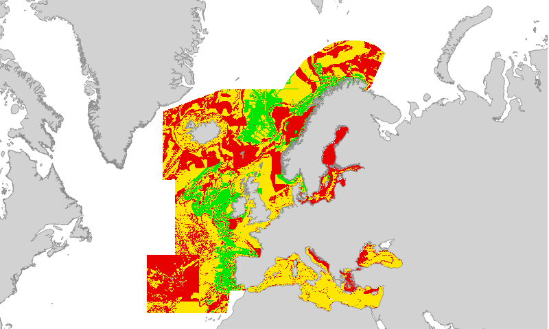
Confidence in the classification of substrate type in the 2019 EUSeaMap broad-scale predictive habitat map. Values are on a range from 1 (Low confidence) to 3 (High confidence). Substrate type is one of the layers of information used to categorise physical habitat types in EUSeaMap; these layers of information are collectively known as 'habitat descriptors'. The substrate layer confidence was obtained from reclassification and standardisation of the confidence scores associated with each primary layer used to create the Substrate types layer. Detailed information on the modelling process for the 2016 is found in section 2.7.2 of the EMODnet Seabed Habitats technical report and its appendices (Populus et al, 2017, link in Resources). We are working on an updated report for the 2019 version. Created by the EMODnet Seabed Habitats project consortium.
-
Oxygen regime class layer in the Black Sea produced by EMODnet Seabed Habitats as an input layer for the 2019 EUSeaMap broad-scale habitat model. The map of oxygen regime classes was produced using underlying potential density anomaly at the seabed and thresholds derived from statistical analyses or expert judgement on known conditions. Detailed information on the modelling process for the 2016 is found in the EMODnet Seabed Habitats technical report and its appendices (Populus et al, 2017, link in Resources). We are working on an updated report for the 2019 version.
-
Layer showing the boundaries used to subset the modelling of EUSeaMap (2019) therefore streamlining the processing. Each region had a specific partner lead within the consortium: Celtic seas & Arctic - JNCC Iberian peninsula & Black Sea - Ifremer Baltic sea - GEUS Mediterranean - ISPRA
-
EUSeaMap (2019) Broad-Scale Predictive Habitat Map - Confidence in classification of salinity regime
Confidence in the classification of salinity regime in the EUSeaMap (2019) broad-scale predictive habitat map. Values are on a range from 1 (Low confidence) to 3 (High confidence). Salinity regime is one of the layers of information used to categorise physical habitat types in the Baltic Sea area of EUSeaMap; these layers of information are collectively known as 'habitat descriptors'. Confidence in the classification of salinity regime at any location is driven by both the confidence in the values of the input variables, and the confidence in the classification based on proximity to, and uncertainty in, the boundary between classes (i.e. areas closer to a boundary between two classes will have lower confidence). Layers are also available showing confidence in the values of the input variables used to model salinity regime. Created by the EMODnet Seabed Habitats project consortium.
-
Salinity regime class layer in the Baltic Sea and Kattegat strait. Produced by EMODnet Seabed Habitats as an input layer for the 2019 EUSeaMap broad-scale habitat model. The map of salinity regime classes was produced using underlying salinity data at the seabed and thresholds derived from statistical analyses or expert judgement on known conditions. Detailed information on the modelling process for the 2016 is found in the EMODnet Seabed Habitats technical report and its appendices (Populus et al, 2017, link in Resources). We are working on an updated report for the 2019 version.
-
Classified seabed substrate types for European seas. Produced by EMODnet Seabed Habitats as an input layer for the 2019 EUSeaMap broad-scale habitat model, based on EMODnet Geology seabed substrate products. The extent of the mapped area includes the Mediterranean Sea, Black Sea, Baltic Sea, and areas of the North Eastern Atlantic extending from the Canary Islands in the south to the Barents Sea in the north. The layer of seabed substrate was produced using data from EMODnet geology 1:100K, 1:250K and 1:1M seabed substrate maps, and integrated with extra substrate feature relevant for habitat mapping (seagrass beds, for example). The Folk 5 classification of substrate is adopted because it is compatible with the EUNIS classification of habitats used in EUSeaMap 2019. Detailed information on the modelling process for the 2016 is found in the EMODnet Seabed Habitats technical report and its appendices (Populus et al, 2017, link in Resources). We are working on an updated report for the 2019 version.
-
Confidence in the classification of energy level in the EUSeaMap (2019) broad-scale predictive habitat map. Values are on a range from 1 (Low confidence) to 3 (High confidence). Energy level is one of the layers of information used to categorise physical habitat types in EUSeaMap; these layers of information are collectively known as 'habitat descriptors'. Confidence in the classification of an energy level at any location is driven by both the confidence in the values of the input variables, and the confidence in the classification based on proximity to, and uncertainty in, the boundary between classes (i.e. areas closer to a boundary between two classes will have lower confidence). Layers are also available showing confidence in the values of the input variables used to model energy levels (kinetic energy at the seabed and wave exposure). Detailed information on the modelling process for the 2016 is found in the EMODnet Seabed Habitats technical report and its appendices (Populus et al, 2017, link in Resources). We are working on an updated report for the 2019 version. Created by the EMODnet Seabed Habitats project consortium.
-
Confidence in the classification of oxygen regime in the EUSeaMap (2019) broad-scale predictive habitat map. Values are on a range from 1 (Low confidence) to 3 (High confidence). Oxygen regime is one of the layers of information used to categorise physical habitat types in the Black Sea area of EUSeaMap; these layers of information are collectively known as 'habitat descriptors'. Confidence in the classification of an energy level at any location is driven by both the confidence in the values of the input variables, and the confidence in the classification based on proximity to, and uncertainty in, the boundary between classes (i.e. areas closer to a boundary between two classes will have lower confidence). Layers are also available showing confidence in the values of the input variables used to model oxygen regime. Created by the EMODnet Seabed Habitats project consortium.
-
Confidence in the classification of biological zones in the EUSeaMap (2019) broad-scale predictive habitat map. Values are on a range from 1 (Low confidence) to 3 (High confidence). Biological Zone is one of the layers of information used to categorise physical habitat types in EUSeaMap; these layers of information are collectively known as 'habitat descriptors'. Confidence in the classification of a Biological Zone at any location is driven by both the confidence in the values of the input variables, and the confidence in the classification based on proximity to, and uncertainty in, the boundary between classes (i.e. areas closer to a boundary between two classes will have lower confidence). Layers are also available showing confidence in the values of the input variables used to model Biological Zones. Detailed information on the modelling process for the 2016 is found in the EMODnet Seabed Habitats technical report and its appendices (Populus et al, 2017, link in Resources). We are working on an updated report for the 2019 version. Created by the EMODnet Seabed Habitats project consortium.
-
Energy class layer produced by EMODnet Seabed Habitats as an input layer for the 2019 EUSeaMap broad-scale habitat model. The extent of the mapped area includes the Baltic Sea, and areas of the North Eastern Atlantic and Arctic extending from the Canary Islands in the south to Norway in the North. The map of energy classes was produced using underlying wave and current data and thresholds derived from statistical analyses or expert judgement on known conditions. Detailed information on the modelling process for the 2016 is found in the EMODnet Seabed Habitats technical report and its appendices (Populus et al, 2017, link in Resources). We are working on an updated report for the 2019 version.